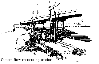
At periods of low flow, the amount of water flowing is measured in cubic feet per second (CFS) by wading to the middle of the creek. When the water is too deep to wade, a measuring device is lowered from the trolly over the middle of the creek, and a measurement is taken.
Other components of this station include the small green building across the creek. A gauge inside records the water level of Bear Creek every half hour. A measuring stick, visible outside the structure, is used to compare and/or back up informtiaon from the inside gauge. The antenna mounted atop the building relays stream-level data, via satellite, to the Bureau of Reclamation and the USGS.
 Medford Station 6: A Tightrope, But Where's the Tightrope Walker?